 Boating US&Canada


Boating US&Canada
World’s Most Popular Marine & Lakes App! A favorite among cruisers, sailors, fishermen and diver...
更多
World’s Most Popular Marine & Lakes App! A favorite among cruisers, sailors, fishermen and diver...
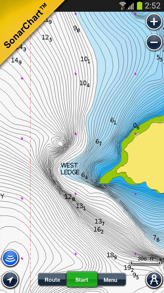
World’s Most Popular Marine & Lakes App! A favorite among cruisers, sailors, fishermen and divers. Find the same detailed charts as on the best GPS plotters. This app includes the overwhelming value of Navionics+. Alternatively, you may have found a free version on the store offering basic features, where Navionics+ can be purchased In-App. NAVIONICS+ includes: √ NAUTICAL CHART for all essential cartographic reference detail. The most accurate and thorough set of information based on Hydrographic Office data, Notices to Mariners, new publications, our own surveys, and reports from users. It provides port plans, safety depth contours, marine services info, tides & currents, navigation aids and more.√ SONARCHART™: The award-winning 1 foot/ 0,5 m HD bathymetry map that reflects ever-changing conditions. Be part of the community and contribute by uploading your sonar logs to enhance it.√ COMMUNITY EDITS made by users (rocks, wrecks, etc.) and shared for all to benefit√ CHART UPDATES: we deliver more than 2,000 updates every day! Take advantage of our updates as frequently as you like√ ADVANCED MAP OPTIONS to highlight Shallow Areas, select Depth Shading, filter Depth Contours, and adjust shorelines to selected Water Level. Includes a Fishing Mode.√ NAVIGATION MODULE for advanced route planning with ETA, distance to arrival, heading to WP, fuel consumption and more!Note: Download detailed maps by zooming in or from Menu>Download Map. Check navionics.com for coverage.
Navionics+ is a one year subscription. At expiration you can renew with a discount of up to 50%. If you don’t renew, you can still use the charts you previously downloaded, along with several free features: TRACK your journey, view speed, distance, time and COG. ROUTES: create and edit, based on speed and fuel consumptionMeasure DISTANCE, add MARKERS, get WIND FORECASTS and sun/moon cyclesMAP OPTIONS: Satellite/Terrain, Safety Depth and Easy View (not on Govt. Chart)SYNC Tracks, Routes & Markers among your mobile devicesMAGAZINES & GUIDES for location-based articles from leading industry publishersGOVT. CHART in USSONARCHART™ LIVE - allows you to create new personal 1ft/0.5 m HD bathymetry maps that display in real time while navigating. Upload your sonar logs to build even better local charts for your area connecting wirelessly to a compatible sounder/plotter.PLOTTER SYNC - NEW! Plotter Sync may also provide access to Dock-to-dock Autorouting, SonarChart Live and Advanced Map Options for your GPS plotter. Learn more at www.navionics.com/en/plotter-sync COVERAGE- Does not include Bermuda, which can be found on Boating Caribbean & South America. Visit navionics.com for the lake list. (only for Usa, US&Canada titles).
Navionics has certified several Android models where the app is designed to load and operate correctly with an OS of 4.0 or higher. Please refer to our Compatibility Guide, which is continuously updated at http://www.navionics.com/en/compatibility/mobile. We cannot guarantee flawless operation or provide support for non-certified devices. ALL SALES ARE FINAL on Google Play.